Landguard Point to Felixstowe Ferry
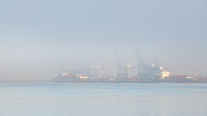 It’s 8.15am as I pull into an almost deserted car park at Landguard point. The fog is swirling across the river thin enough in places to allow the weak winter sun to penetrate but thick enough to partially obscure the container ships on their berths.
I am here to walk the first part of the Suffolk Coast Path, a 60 mile route between Felixstowe and Lowestoft. I am walking the route in 9 sections as part of a coastal photography project. A journey along the Suffolk Coast seeking silence, connection and a deeper immersion in nature. I am also looking forward to discovering sections that I have never walked before. The first part of the journey is a 6.5 mile route between Landguard Point and Felixstowe Ferry.
As I begin my walk the fog gives the morning an overwhelming sense of calm. There is not a breath of wind and the river, looking beautiful in pale blue, lazily laps the shore. Behind me I can hear the hum and clatter of the docks as I walk south towards the old pier, the most southerly part of the Suffolk coast.
I have brought my camera and one lens with me today, my 70-200mm. This is not a photograph walk as such, I am travelling lite, as I don’t have a tripod or any filers with me. My photography will be more of a sketch book of my journey.
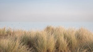 Landguard point is a fascinating place of contrasts. As I leave the docks I head into the nature reserve, a coastal grassland full of rabbits enjoying the morning peace. It seems too early for dog walkers and this part of the reserve is deserted. I arrive at the beach and spend some time photographing the dew on some of the coastal plants and the light in the marram grass.
I turn left and head along the beach towards Felixstowe town. Conditions have cleared a little around me and the sun is shining but ahead I can see a dense bank of fog beyond the pier which obscures the town and the coast beyond.
I can still hear the port but it ceases to dominate as I walk past the old Martello tower, now a coast watch station, and join the dog walkers and joggers on the prom.
Passing the pier the fog envelopes me again and feel the temperate drop as the sun vanishes. Photography in these conditions is fun and challenging as in places the fog is too thick to distinguish much detail.
 I continue my journey past the Spa Pavilion, the seafront gardens and on towards Cobbolds Point which is best known for its rather strange looking sea defences that head out from the beach in two separate directions. The seafront is busy despite the fog and chilly conditions and I continue past the point and climb the steps to the clifftop. The section of the beach that I have just left is only walkable at low tide and as I only have an hour before high-water I decide it is best to take the detour. I am glad that I did because as I reach the car park and green at the top of Golf road I am met with a wonderful looking fogbow which has formed over the houses. Unfortunately I have the wrong lens on my camera for a shot so rely on my phone to capture this uncommon phenomenon.
The sun is now shining and the walk to Felixstowe Ferry, past the golf course and along the entrance to the Deben is beautiful. The high tide obscures most of the knolls which lie in the river entrance but the view north towards Bawdsey manor is lovely. Part of the sea wall just before the ferry is closed for renovations with excavators adding to the rock armour which is evident along large parts of this coast – an ugly but necessary defence against rising sea levels.
Arriving at the ferry I sit on the sea wall in the sunshine and watch the water gushing and swirling along the channel towards Woodbridge. I looked across the river to Bawdsey Quay on the opposite bank where the next part of my journey along the Suffolk Coast path will begin.